

Turning Land Data
into Smarter Decisions
Understand your land. Analyze its potential. Make better decisions.MyLand Intelligence is a powerful land intelligence and GIS platform that brings cadastral data,land records, spatial information, terrain, infrastructure and custom datasets together in one interactive environment.
Enterprise GIS Capabilities Built for Precision
A powerful suite of spatial intelligence tools to query Controlled Areas, verify MC Limits, analyze Sector/Zone layouts, inspect Circle Rates, and export vector CAD reports.
GIS Spatial & Sector Boundary Engine
High-precision geospatial vector overlays providing real-time visualization of Controlled Areas, Municipal Limits, Sector & Zone layouts, and exact GPS Centroid Coordinates mapped over satellite telemetry.
- Sub-meter boundary spatial accuracy
- Real-time GIS vector layer toggles
- Exact GPS centroid coordinate markers
Automated Land Reports & Circle Rates
Generate executive land audit reports covering Area Measurements, Sector/Zone designations, municipal clearances, and prevailing Circle Rates in under 30 seconds.
- Automated Circle Rate valuation
- Multi-unit area measurement summary
- Instant printable PDF downloads
Controlled Areas & MC Limits Index
Access digitized municipal Corporation (MC Limits) boundaries, urban development master plans, and regulated Controlled Area restrictions.
- Pan-India municipal coverage
- Development zone restriction flags
- Buffer distance & setback audits
Multi-Format Data & Export Engine
Seamlessly export spatial land boundaries, parcel attribute metadata, and detailed site intelligence reports directly into Google Earth Pro KML vectors, structured CSV spreadsheets, and high-resolution PDF documents.
- Google Earth Pro KML spatial vectors
- Structured CSV exports for data analysis
- Printable 300 DPI executive PDF reports
Enterprise Workspaces & Team Quotas
Establish corporate workspaces. Invite field survey team members, allocate shared Area Measurements quotas, and audit all queries from a centralized dashboard.
- Multi-user team member seats
- Granular Area Measurement limits
- Centralized security audit logs
Precision Area Measurements & Converter
Convert land parcel dimensions across standard regional units (Acres, Bigha, Kanal, Marla, Hectares, Sq. Meters, Sq. Feet) with 100% mathematical accuracy.
- Instant unit area conversion
- State-specific regional factors
- Perimeter & acreage calculations
How to Use the MLi Platform in 4 Simple Steps
Follow this complete visual walkthrough to register your account, select a subscription plan, query spatial land parcels on interactive GIS maps, and export automated analytical reports.
1. Register Account & Verify OTP
- Click Get Started or Register on the top navigation bar.
- Choose Individual Owner or Enterprise Organization mode.
- Enter your 10-digit mobile number & verify via instant 6-digit SMS OTP.
- Set up your full name, email, and security password.
2. Select & Purchase Subscription
- Go to Pricing & Plans from top menu or user dashboard.
- Choose plan: Basic Plan, Standard Plan, Premium Plan, Enterprise Plan, or Ultimate Plan.
- Click Buy/Upgrade Plan to launch Razorpay secure payment gateway.
- Pay via UPI, Debit/Credit Card, or NetBanking to activate quota instantly.
3. Search Parcels & Explore GIS Map
- Open GIS Map Visualizer in User Dashboard.
- Use Form Search: Select State, District, Tehsil & Village.
- Or Point Query: Click directly on satellite/cadastral polygon boundary.
- Inspect Controlled Areas, area measurements, MC Limits,Sector/Zone,Circle Rates, & GPS coordinates.
4. Generate PDF, CSV & KML Reports
- Select format: PDF Document, CSV Sheet, or KML Map File.
- Click Compile & Generate Report to initiate background compilation.
- Track compilation status in Report Generation Log & History.
- Click Download to export file, or Delete / Cancel anytime.
Tailored Spatial Intelligence for Every Sector
Whether you are acquiring commercial acreage, planning urban development, or evaluating property zones, MLi provides dedicated tools for your domain.
Real Estate & Commercial Developers
Audit Controlled Areas, verify MC Limits, inspect Sector/Zone master plans, and check prevailing Circle Rates before making acquisition offers.
Urban Planning & Infrastructure Surveys
Evaluate Area Measurements, road frontage, MC Limits boundary alignments, and GPS Coordinates for project planning.
Individual Owners & Property Buyers
Instantly query Sector/Zone designations, verify MC Limits boundaries, check official Circle Rates, and download executive PDF land reports.
Solar Energy & Industrial Projects
Scan vast contiguous land parcels for Controlled Areas clearance, power grid line distance, highway access, and precise GPS Coordinates.
What You Unlock With the MLi Portal
Access complete spatial parcel intelligence, Controlled Areas, MC Limits, Sector/Zone layouts, Circle Rates, and Area Measurements tools in one unified dashboard.
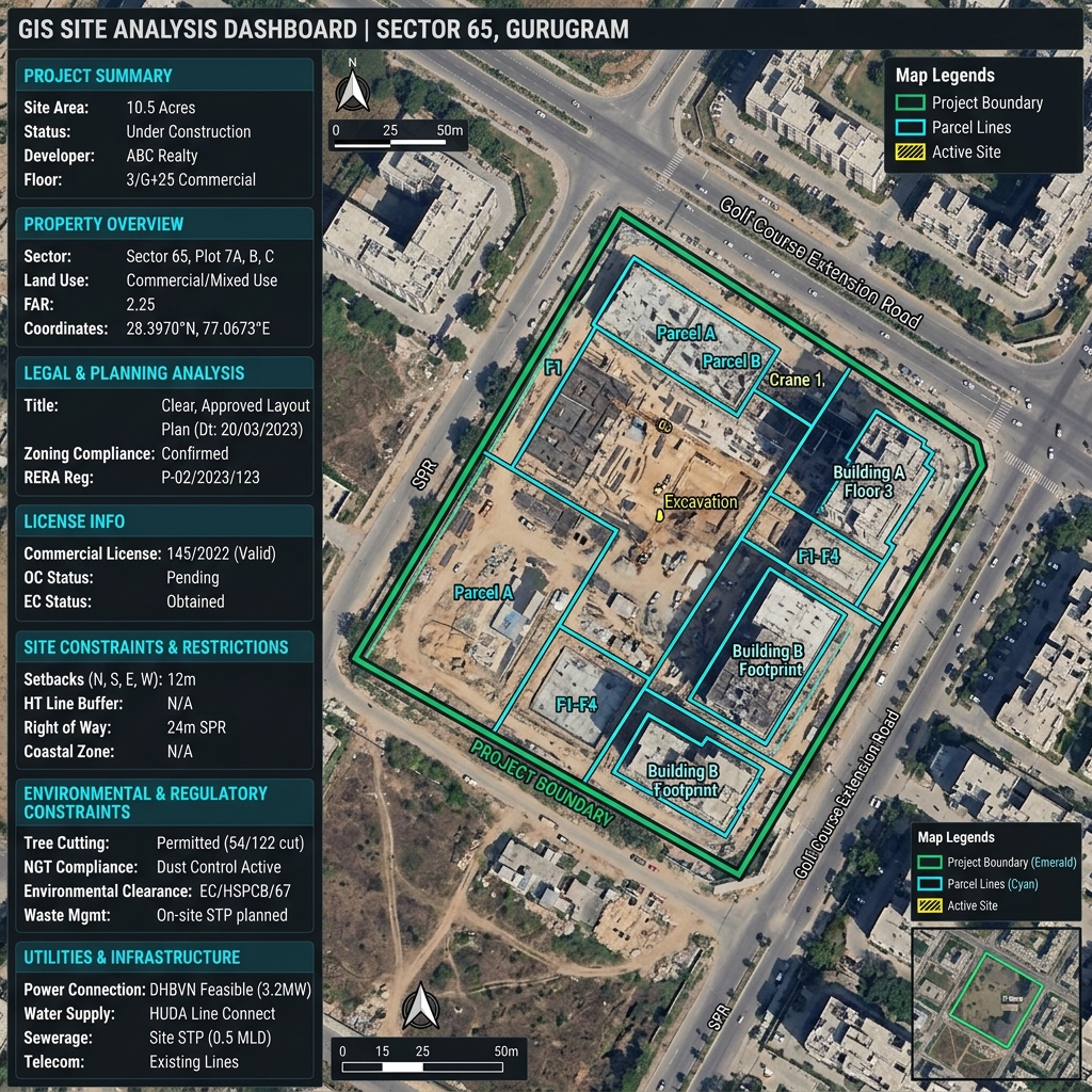
Comprehensive 7-Module Land Audit Report
Every MLi land report delivers 7 structured analytical modules for complete spatial, legal, and financial clarity:
1. Executive Summary
Executive valuation summary, total acreage, prevailing Circle Rates, and overall parcel viability score.
2. Property Overview
Georeferenced GPS centroid coordinates, Sector/Zone layout, MC Limits status, and Area Measurements.
3. Legal & Planning Analysis
Controlled Area Master Plan compliance, urban development zoning, FAR, and height allowances.
4. License Info
DTCP Haryana development licenses, commercial site approval status, and sanction reference numbers.
5. Site Constraints & Restrictions
Road widening Right-of-Way (ROW) setbacks, building line buffers, and utility corridor restrictions.
6. Environmental & Regulatory Constraints
Eco-sensitive buffer distances, green belt demarcations, and water body distance audits.
7. Utilities & Infrastructure
Proximity to electrical substations, municipal water/sewerage connections, and arterial road access.
Instant Land Area Unit Converter
Calculate Area Measurements across standard units before conducting spatial queries.
What You Get In Every MLi Land Audit Report
Our standardized executive land audit reports deliver 12 complete analytical sections compiled into print-ready PDF, CSV, and KML.
1. Cover Page & Report Metadata
Project title, unique Report ID, timestamp, village/tehsil/district location.
2. Legal Disclaimer & Scope
Formal regulatory scope, data sources, and due diligence assessment terms.
3. Executive Summary
Total Area Measurements, prevailing Circle Rates, and zoning recommendations.
4. Property Overview
Location boundaries, urbanizable status, Sector/Zone layout, & zoning tier.
5. Parcel Summary & Feasibility
Individual plot numbers, area calculations, land use feasibility, and Circle Rates.
6. Utilities & Infrastructure Audit
Audit of Gas Lines, Water Lines, Power Lines, Sewerage, Drain, OFC Fiber, & Towers.
7. GIS Geometry & Perimeter
Exact shape area (Sqm / Acres), side dimensions, and total boundary perimeter.
8. Legal & Master Plan Analysis
Controlled Areas, Green Belt buffers, TOD, NCZ, & building height restrictions.
9. Development License Info
License code, sanction reference numbers, issue dates, and developer particulars.
10. Site Constraints & Restrictions
Airport Funnel Zone, Airport Influence, Defense Restrictions, & Heritage buffers.
11. Environmental & Regulatory Constraints
Wind Direction, Coastal Zone (CRZ), Eco-Sensitive Zones, Soil Stability, & Seismic Zone.
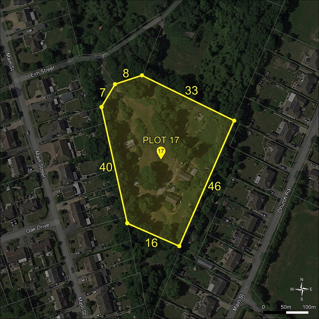
12. High-Res Satellite Maps & Annexure
CAD parcel boundary vector layout overlay with edge dimensions georeferenced on satellite maps.
256-Bit SSL Encryption
All parcel queries and workspace audit logs are encrypted in transit and at rest.
Razorpay Secured Payments
PCI-DSS Level 1 compliant gateway processing for UPI, Credit/Debit cards & NetBanking.
Multi-Format Vector Exports
Download high-res PDF reports, CSV spreadsheets, and KML map files.
Enterprise Workspace Isolation
Manage organization team seats, assign area limits, and audit member activity.
Trusted By Land Professionals & Developers
"MLi platform has transformed how we conduct pre-construction site feasibility and khasra boundary audits. The high-resolution GIS satellite overlays and automated parcel reports have saved our surveying team over 200 hours of manual verification work."
"For property title verification and due diligence across urban land sectors, MLi is indispensable. I can query any khasra parcel, inspect exact boundary dimensions, verify government circle rates, and export an official PDF audit report in minutes."
"The precision of MLi's GIS sector overlays and municipal limit boundaries is remarkable. Being able to export high-definition KML vectors directly to Google Earth Pro and structured CSV reports has streamlined our acquisition planning completely."
Got Questions? We Have Answers
Everything you need to know about MLi cadastral mapping, subscription quotas, and report generation.
What are Controlled Areas, MC Limits, and Sector/Zone boundaries?
Controlled Areas and MC Limits represent official municipal and urban development boundaries. Sector/Zone layouts classify land usage plans and infrastructure zoning. MLi indexes these boundaries with high-precision GPS Coordinates.
How accurate are the CAD GIS map overlays and GPS Coordinates?
MLi digitizes official state development maps and georeferences them over high-resolution satellite imagery (Sentinel/ArcGIS/OpenStreetMap) with up to 99.8% spatial boundary accuracy and exact GPS Coordinates.
Are Circle Rates and Area Measurements included in land reports?
Yes! Every generated land report includes detailed Area Measurements, Sector/Zone classifications, and prevailing Circle Rates.
Can I export reports to Google Earth or PDF?
Yes! Reports can be generated in PDF (for print/sharing), CSV (for Excel analysis), or KML format which opens seamlessly in Google Earth Pro.
How do Enterprise Organization team seats work?
Enterprise account owners can invite team members (field engineers, land officers) into their organizational workspace, assign individual area limits, and audit all action logs centrally.
Is my land search history confidential?
Absolutely. All user queries, saved reports, and downloaded KML files are strictly private to your account and protected by 256-bit SSL encryption. You can also delete your report history anytime.